
A Milder Seasonal Horizon with Scattered Heavy Precipitation
As communities across the country remember the severe cold snaps and disruptions of previous winters, a newly released long-term outlook offers a shift in tone. The iconic publication, the Old Farmer’s Almanac, projects that the 2026–2027 winter season will bring relatively gentle conditions to a significant portion of the United States. Temperatures are expected to hover around or above seasonal averages for many regions, though active weather systems will still bring periodic bursts of rain and snow across specific corridors.
While broad swathes of the nation are set to experience temperate conditions, the prediction points to elevated moisture levels across vast parts of the West, South, Midwest, and Florida. Conversely, portions of the Eastern Seaboard, the Plains, and the Southwest could see lower precipitation levels than usual. Snow lovers in the Appalachians, parts of the Northeast, selected Western regions, and Alaska can still prepare for notable accumulation throughout the season.
Atmospheric Drivers: El Niño and the Polar Vortex
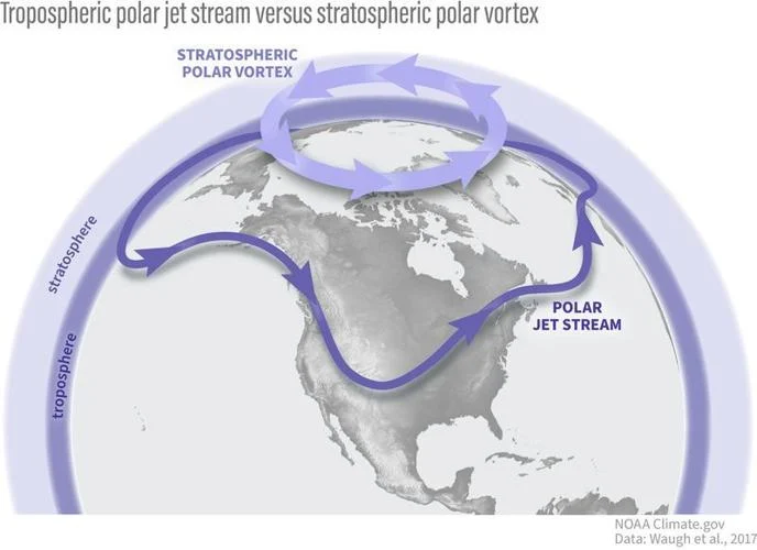
Forecasting weather months in advance remains a complex science, particularly with competing ocean and atmospheric patterns at play. A primary factor shaping this coming winter is a strengthening El Niño event, characterized by the natural heating of surface waters in the equatorial Pacific Ocean. When El Niño interacts with the stratospheric polar vortex and atmospheric jet streams, it can significantly alter temperature and storm trajectories.
Should El Niño cause fluctuations in the polar vortex, freezing air masses usually locked over Canada can slip southward into parts of the continental United States. This potential setup leaves room for sudden cold snaps, particularly across the eastern half of the nation. The competing publication, the Farmers’ Almanac, similarly projects an active, wet winter, warning that northern states could face sharp, brief winter blasts while the Northeast copes with a damp mix of snow, sleet, and freezing rain.
Mainstream Science Meets Traditional Forecasting
The annual arrival of long-range almanacs often highlights a persistent divide between traditional weather guides and professional meteorology. Established forecasters generally view almanac predictions with a degree of skepticism. Critics emphasize that detailed seasonal forecasts produced before late September lack reliable scientific precision, urging the public to treat early predictions with caution.
Nevertheless, some aspects of the almanac’s vision line up with official government models. The National Weather Service Climate Prediction Center’s December through February outlook similarly indicates a likelihood of near-to-above-normal temperatures for wide stretches of the country. Mainstream outlets like AccuWeather typically hold off on releasing their detailed winter outlooks until October, waiting for additional data regarding marine heatwaves, sea surface temperatures, and polar vortex stability.
Regional Winter Outlook Across the United States
The Old Farmer’s Almanac breaks down its seasonal projections into specific geographical sectors, highlighting distinctly varied weather stories across the country.
The West Coast and Pacific Northwest
Residents in western Washington, Oregon, and northern California can anticipate higher-than-average winter temperatures paired with elevated rainfall and snowfall. The heaviest snow events are slated for late December, mid-January, and mid-February. Farther south across California, a generally warm and damp pattern is expected, with mountain regions seeing solid snowfall. The stormiest stretches for the Golden State are anticipated in late December, mid-January, late February, and late March.
The Northeast and Mid-Atlantic
The northeastern states face a split narrative: milder temperatures toward the north, but colder conditions further south. The sharpest dips in temperature are predicted for early to mid-January. Snowfall in this zone is expected to exceed norms in southern areas while staying sparse to the north. Across the Atlantic Corridor—stretching from Massachusetts down through Virginia—milder overall weather and lower precipitation are forecasted, though notable snow windows could materialize in late November, mid-January, late February, and late March.
The Midwest and Great Lakes
In the Lower Lakes region, comprising parts of Michigan, Wisconsin, Illinois, and nearby states, temperatures are projected to stay mostly mild, accompanied by above-average precipitation but standard to low snowfall totals. The coldest spells are slated for early January and early February. Meanwhile, the Ohio Valley may endure colder-than-average stretches, particularly in mid- to late January, with snowfall leaning slightly below average.
The South and Sunbelt
Warmer-than-usual conditions are slated for much of the Deep South and Southeast. Florida is likely to experience a mild winter, with brief chilling trends expected in early December and early January. Rainfall in the Sunshine State will likely be higher in the north and lighter toward the southern tip. Texas and Oklahoma are set for a warm season with standard snowfall chances concentrated in early and late January as well as early February.
The Plains, Intermountain West, and Southwest
Above-normal temperatures are expected throughout the High Plains and Desert Southwest, with overall precipitation running below standard levels. In contrast, the Intermountain region—spanning areas of Washington, Oregon, Idaho, Nevada, and neighboring states—can prepare for a mild but snowy winter, with major snow periods expected in late November, late December, and early February.
Alaska and Hawaii
Alaska is slated for a milder winter overall, accompanied by above-normal precipitation in the north and heavier snowfall across the state, particularly during mid-November, January, mid-February, and late March. Hawaii stands out with a forecast calling for cooler-than-average weather and higher rainfall, with unsettled periods peaking in mid-December, mid-January, and late February.
Evaluating Long-Range Forecast Methodology
The Old Farmer’s Almanac maintains that its forecasting technique relies on a proprietary mathematical formula first established by founder Robert B. Thomas in 1792. While the publisher asserts that it updates this method using modern technology, satellite data, and solar activity patterns, meteorologists reiterate that long-term atmospheric dynamics are far too volatile to predict with complete certainty months in advance.
As winter approaches, experts recommend using these long-range projections as broad indicators rather than absolute schedules, advising residents to stay tuned to local meteorological updates as the season unfolds.
Leave a comment